Eastern New Orleans – Bayou Sauvage NWR

Overview Map of Birding Spots in New Orleans East
New Orleans East offers the best birding in New Orleans, but much of it is undergoing rapid development. Unfortunately, there has been a great deal of clearing of woods and draining of marsh in this part of the city. The establishment of the Bayou Sauvage National Wildlife Refuge has protected much of the land in the extreme eastern part of the city.
1. Joe Brown Park: To reach the park from I-10, take the Read Boulevard exit, turn right (south), and turn right into the park just past the stop light at Lake Forest Blvd. Check the edges of the lagoons for Anhinga, Green Heron, Black and Yellow Crowned Night Herons and the weedy edges for warblers and sparrows in winter.
2. Paris Road and Hayne Blvd.: From I-10 take the Paris Road exit north, and follow Paris Road (Hwy. 47) until it makes a 90 degree turn at the lake. This is the intersection of Paris Road and Hayne Blvd. Park and walk up on top of the levee to look over the marsh.
This is one of the most reliable spots for Purple Gallinule (summer) in the area, and such birds as Common Gallinule, Northern Harrier, Marsh Wren, and rails can also be seen here. The trees in this area have trapped several western vagrants during the winter, though development is cutting into this woodland deeply. Sometimes the gate on top of the lake levee is open, allowing you to drive along the lakeshore to observe rafts of wintering ducks. You can, in any case, walk it, watching the slough on your right (south) and the willows along it.
3. Irish Bayou Lagoon and South Point Levee: Take I-10 east until you are about to drive out over Lake Pontchartrain. Take the Irish Bayou-US 11 exit here, turn north over the overpass, and then turn left on the old road just before the lake. Be careful not to take the I-10 entrance, but the road just beyond it just before the bridge starts across the lake. You can bird the lake after you make the turn.
Continue west on this road to a low bridge. The open lagoon or bay to the north should be checked here for ducks. The wax myrtles along the road can be squeaked for vagrants in winter. Continue a few yards west to the north-south levee, and park. You will see Bayou Sauvage Refuge signs in the vicinity. You can walk the levee or the road beside it all the way to the lake, birding the willows on the left or wax myrtles on the right. This is most interesting in winter when there may be sparrows, waterfowl in the lagoon to the right, raptors overhead (especially in migration), etc.
4. US 11 South: From I-10 take the same Irish Bayou-US 11 exit described above, but turn south and drive through the small fishing community of Irish Bayou. After you cross a levee, look for ponds on both sides of the road. This area is the heart of the new Bayou Sauvage National Wildlife Refuge (see below). These ponds are good for waterfowl, wading birds and shorebirds. Keep an eye out for raptors over the marsh and along the road. Rough-legged Hawk has been seen in this area in winter. See the description of the Bayou Sauvage ridge below.
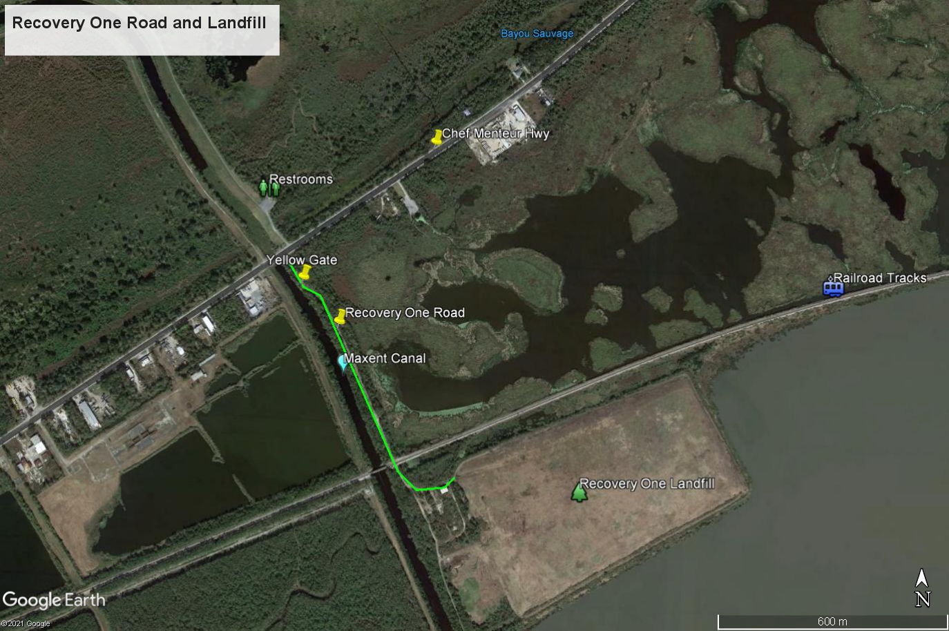
5. Recovery One Road and Landfill: If approaching from the east on US 11, turn west (right) on US 90 and drive for 1.9 miles. If approaching from the west, at the junction of I-510 and Chef Menteur Hwy/US 90, continue east on Chef Menteur Hwy./US 90 for 4.0 miles. The paved Recovery One Road is on the south side of the highway, immediately after you cross the Maxent Canal. Recovery One Road is also across the street from the Ridge Trail entrance to the Bayou Sauvage NWR. Park at the start of Recovery One Road, outside of the yellow gate. Walk south here, paralleling the Maxent Canal, toward the railroad tracks (a half-mile walk). There are ponds and marshes on the east side of road. The best way to see the area is to walk the railroad tracks, but proceed cautiously, as the tracks are heavily used. This is a good area for rails, gallinules, Least Bittern and wintering waterfowl. When water levels are right, this is an ideal site for shorebirds as well. Groove-billed Anis have been seen here in winter. Or continue southward, crossing the railroad tracks and bird the Recovery One Landfill to the east. Ash-throated and Brown-crested Flycatchers have been seen in winter near and on the landfill. LeConte’s Sparrows are sometimes here in winter. Painted Buntings and Blue Grosbeaks now nest here in summer.
6. Industrial Parkway: If you are coming from Recovery One, drive back toward New Orleans (west) on US 90 to the first stoplight, and turn left (south) onto Industrial Parkway. From New Orleans, drive east on US 90, and turn right (south) at the second stoplight east of Michoud Boulevard onto the same Industrial Parkway. There are two north-south roads running through this large industrial park and an east-west road on the southern end. There are also two or three side roads which can be explored for raptors, and perhaps shorebirds.
Bayou Sauvage National Wildlife Refuge
Refuge Map and Information: https://www.fws.gov/refuge/bayou-sauvage-urban
Bayou Sauvage National Wildlife Refuge, with 23,000 acres of woods, swamp, and marsh, is the largest urban refuge in the country. Although it is still in its formative stages, and there is no interpretive center yet, it offers diverse birding possibilities at any season (though least interesting in midsummer).
Although the centerpiece is the area around Bayou Sauvage itself, along US 90 in the eastern part of the city, it stretches from the shore of Lake Pontchartrain on the north to the Intercoastal Waterway on the south. The refuge can best be reached by taking I-10 east to Paris Road, exiting south toward Chalmette and then turning east (left) on US 90 (Chef Menteur Hwy.). After 4 miles, passing a water tower on the left, you will see a sign on the left announcing Bayou Sauvage National Wildlife Refuge and the Ridge Trail. There is a parking lot with bathrooms, a shelter, and a loop-trail boardwalk trail which leads about 3/4 mile through woods with palmetto understory to an overlook which gives views of some marsh, swamp, and open water.
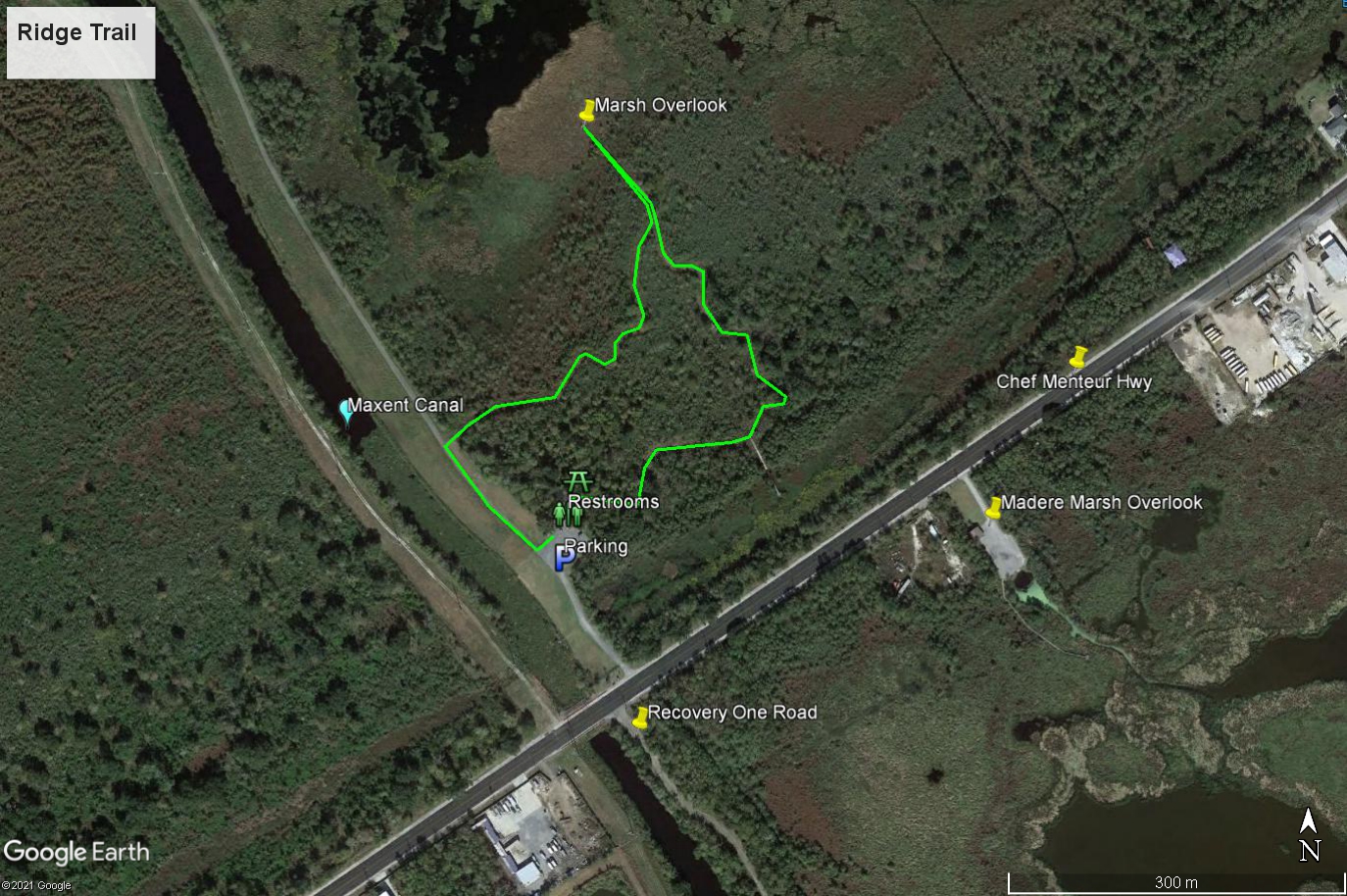
Instead of taking the Ridge Trail, you can walk the Maxent Levee to the north, keeping your eyes on the lagoons to your right for water birds and checking the willows for passerines. Ash-throated Flycatchers have been seen on the Ridge or levee trails on several occasions in fall or winter. The Recovery One landfill, described above, is just across US 90, at the end of a short paved road.
About 1-1/2 miles further east is the intersection of US 90 and US 11, known as Powers Junction. Turn left (north) onto Highway 11, and after about 100 yards, park on either side of the road at a spot where on the left there are some concrete barricades. Here you can walk the ridge to the west for at least several hundred yards along an unmarked, dirt trail. These woods are most interesting in migration and winter. And on the east side of US 11, it is often rewarding to also walk a short, unmarked dirt path to the barrow pit lake where Roseate Spoonbills and other waders may sometimes be observed.

Returning to US 11, drive through the refuge, looking for waders and ducks on either side of the road. There are a couple of places where good views of marshy lagoons can be had by scoping from the roadside and looking west. Waders, ducks, shorebirds, and gulls and terns may be seen, depending on water level. You can continue up highway 11 to Irish Bayou, take the overpass over I-10 and then an immediate left short of the US 11 bridge to Slidell, to the South Point levee area describe in #3, above, also part of the refuge.