The Marguerite Moffett Audubon Sanctuary
 The Marguerite Moffett Audubon Sanctuary protects 108 acres of brackish marsh and shallow open water on the west side of Hwy. LA 56 near Chauvin, Louisiana, in Terrebonne Parish, along the banks of Bayou Petit Caillou.
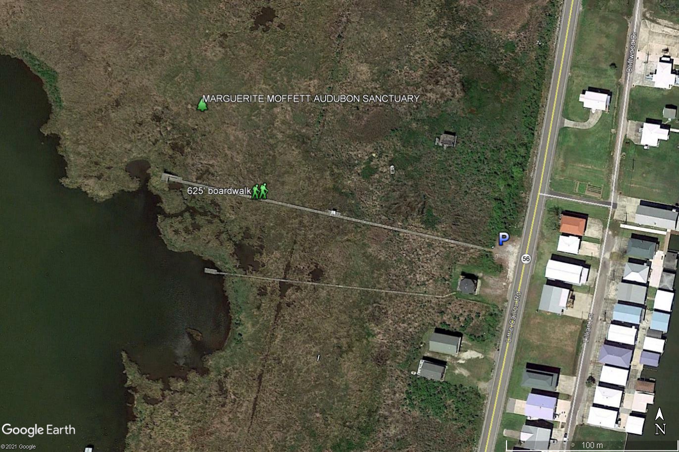
Public Amenities: TEMPORARILY CLOSED FOR REPAIRS! A small parking area on Highway 56 provides access a 625-foot-long elevated boardwalk leading through marsh to on overlook-observation platform providing views of Lake Quitman.
Our Partners: Our partners at this Sanctuary include the Barataria-Terrebonne National Estuary Program (BTNEP), Terrebonne Parish, Houma Area Convention and Visitors Bureau, Louisiana Recreational Trails Program, Gulf Coast Bird Observatory and the Terrebonne Bird Club. We are especially indebted to Richard DeMay of BTNEP for devoting much time and energy to the boardwalk trail.
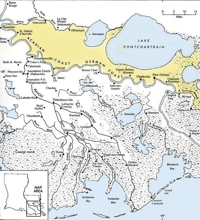
Overview: The sanctuary is located within a pocket of wetlands nestled between Bayou Petit Caillou on the east, and bayous Grand Caillou and Sale to the west and south. These three bayous, and numerous others in Terrebonne Parish, were part of the forking, braided network of the Mississippi River delta – they formed dis-tributary channels of the river.
When Europeans arrived in Louisiana in the early 18th century, the Mississippi River forked at present day Donaldsonville. That right fork was named Bayou Lafourche (The Fork). At present day Thibodaux, Bayou Lafourche also had a right fork, named Bayou Terrebonne (Good Land). Once again, at what was now Houma, Bayou Terrebonne itself divided into multiple channels: Bayou Pointe aux Chenes (Oak Point) to the east and bayous Petit and Grand Caillou (Little and Big Pebble), and Bayou du Large (Wide Bayou) to the west. Finally, just below Dulac, Bayou Grand Caillou forked into Bayou Sale (Muddy Bayou) which rejoined Bayou Petit Caillou just downstream of the Sanctuary.
 Because there was fresh, muddy sediment laden river water flowing through these bayous, there were baldcypress swamps and freshwater marshes here, nourished by spring floods which overflowed the natural levees lining the banks of the bayous. (Natural levees form because during a flood the heavier sediments drop out first, building up the bayou banks, while lighter, finer sediments are carried far from the stream, nourishing surrounding swamps and marshes.)
But the settlers along the natural levees grew tired of the floods. In 1904-05 Bayou Lafourche was cut off at Donaldsonville—it no longer carried the water and sediment of the great river. Eventually upper Bayou Terrebonne silted in and the lower bayous became arms of the sea, slowly moving rainfall south, while becoming tidal arms of the Gulf. Without new sediment and steady freshwater the swamps began to die and freshwater marsh plants were replaced by open or salt tolerant species. Then a flurry of canal dredging, for drainage, logging, navigation, and especially for oil and gas drilling and transport, transformed the area. Salty Gulf water moved in.
Here in the enclosed basin between the bayous there used to be swamp to the north, freshwater marsh to the south, and two interior lakes—Boudreaux and Quitman. But the salt changed everything—today you can’t tell where one lake ends and the next begins. The swamp and most of the marsh is gone. What remains are more salt tolerant marshes growing on the flanks of the bayou natural levees, as here at Moffett Sanctuary.
While the pace of change that occurred here was unnatural and destructive, the process of change, from fresh to salty, from solid ground to open water, is a natural process, part of the delta cycle. And because the process is natural, nature adapts, and today we have here a thriving ecosystem, with plants and animals adapted to the saltier conditions. Here, as elsewhere in the delta, nature will recover if given the opportunity.
For more information about the delta cycle, how we interrupted it, what we’ve lost, and the prospects for the restoration of the Louisiana coast, visit:
http://www.mississippiriverdelta.org/
http://www.coastalmasterplan.la.gov/
https://btnep.org/
http://www.restoreorretreat.org/
http://www.americaswetland.com/
 Important Bird Area
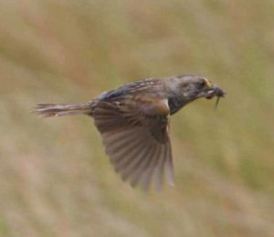
The Sanctuary’s intermediate to brackish marsh provides important nesting habitat for such sought after species as Least Bittern, Clapper Rail, and Seaside Sparrow. Scan from the platform for herons, egrets, ibis and Roseate Spoonbills flying past or wading the marsh or shallow water, ducks and White Pelicans spending the winter, and Brown Pelicans, terns and gulls patrolling the lake and the bayou year round. Elusive mink and river otter hunt throughout the marsh, while saltmarsh snakes and diamondback terrapins bask in the sun.
The Marguerite Moffett Audubon Sanctuary is part of the Barataria-Terrebonne Important Bird Area, recognized at the Global and Continental level for least 12 species of birds (https://www.audubon.org/important-bird-areas/barataria-terrebonne). This Sanctuary is one of the featured destinations of the America’s Wetland Birding Trail that spans the entire Louisiana coast from Texas to Mississippi. http://www.louisianatravel.com/sites/all/themes/mmg_aurora/img/louisiana_birding_trails/terrebonne_loop.pdf
The Sanctuary is an eBird Hot Spot. Please share your bird observations and contribute to our Sanctuary database by selecting Marguerite Moffett Sanctuary from the Hot Spot list when entering your bird list. https://ebird.org/hotspots
The Marguerite Moffett Audubon Sanctuary was Orleans Audubon’s second sanctuary, created on December 31, 2001, with a generous land donation from Dr. Marcel J. Remson and Mrs. Billie Cole Remson. The Sanctuary was expanded in August of 2003 with an additional donation of land by the Remsons. It is named to honor the memory of Dr. Remson’s aunt, Marguerite Moffett.
Information for Visitors: Free, open to the public daily, parking available, hiking trail (boardwalk), handicapped access, lookout observation deck/viewing area. No restrooms.
Directions:
The MMAS is located in Terrebonne Parish, south of Chauvin, on the west side of Hwy. 56. The parking lot is 0.6 miles south of the Robinson Canal on Hwy. 56 and 1.1 mile north of the junction of Highways 56 and 57.
Geographic Coordinates: 29.32355 N, -90.64500 W (parking area along Hwy. 56)
Physical address: 7026 Hwy. 56 (Little Caillou Rd.), Chauvin, LA 70344.
Mailing address: Orleans Audubon Society, 64340 Fogg Lane, Pearl River, LA 70452-5206.
Nearby attractions:
LUMCON https://lumcon.edu/visit-and-directions/
Kenny Hill Sculpture Garden on Bayou Petit Caillou https://www.louisianatravel.com/articles/sculpture-garden-folk-art-gem-chauvin
Pointe aux Chenes Wildlife Management Area https://www.wlf.louisiana.gov/page/pointeauxchenes
Chauvin Area Map

Marguerite Moffett Audubon Sanctuary Map