New Orleans City Park and Lake Vista
New Orleans City Park is one of the largest urban parks in the U.S., with 1500 acres of stately old live oaks, formal gardens, mixed hardwoods, brush, and field habitats. The park also contains many lagoons, and Bayou St. John borders the eastern edge of the park. The park is accessible by public transit, via the Canal Street/Carrollton Ave. street car line. By car it can be reached by driving up Canal Street to the cemeteries, taking a right on City Park Ave, and driving about a half mile to the edge of the park at Marconi Drive. Alternatively, take I-10 west to Metairie Road and exit right onto City Park Ave. You can also drive directly up Esplanade Ave. from the lower end of the French Quarter to the park. During fall and spring after a rainy night, any large oak is likely to produce many species of warblers, vireos and other passerines. In winter the lagoons and Bayou St. John attract a wide variety of waterfowl. Wading birds may be seen throughout the year around the lagoons.
1. New Orleans Museum of Art: This is the area closest to the City Park street car stop. It is an open, high-use area with many oak trees and palm trees. The lagoons here contain mostly domestic ducks, but you might find Ring-necked Ducks or Lesser Scaup in winter. Landbirds will be typical resident species, but in migration or in winter you might find something more interesting.
2. New Orleans Botanical Garden/Bestoff Sculpture Garden: Walk through this area checking the many live oak trees. The botanical garden is open Tuesday through Sunday 10:00 a.m. until 4:30 p.m. with a fee. In migration and winter, hummingbirds can sometimes be seen in the hummingbird/butterfly garden. If you walk around the fence to the back of the botanical garden, you will enter one of the best oak groves in the area. Lunch can be purchased in the Casino Building.
3. Scout Island: From the intersection of Marconi Drive and Harrison Avenue (which is reached by car), continue east on Harrison Avenue Across the first bridge, then look for a chain link gate on the right (south) side of the road. This is the entrance to Scout Island. You can find pines, hardwoods, open fields, and views of some lagoons on the island. Follow a trail on the left along the lagoon.
4. Couturie Forest: Continue east on Harrison Avenue, cross a second bridge, to a parking lot on the left (north) side of the road. Enter these woods and follow the network of trails transecting the area. It is easy to follow the trail along the lagoon on the left. The hill (tallest spot in New Orleans!) is also worth climbing and checking. As is always the case, open areas and edges are usually the best, but there is extensive undergrowth which can be good for low-feeding species. Much of this area is secluded so caution should be exercised; single females probably should elect more public areas. This is by far the best birding spot in the park during migration.
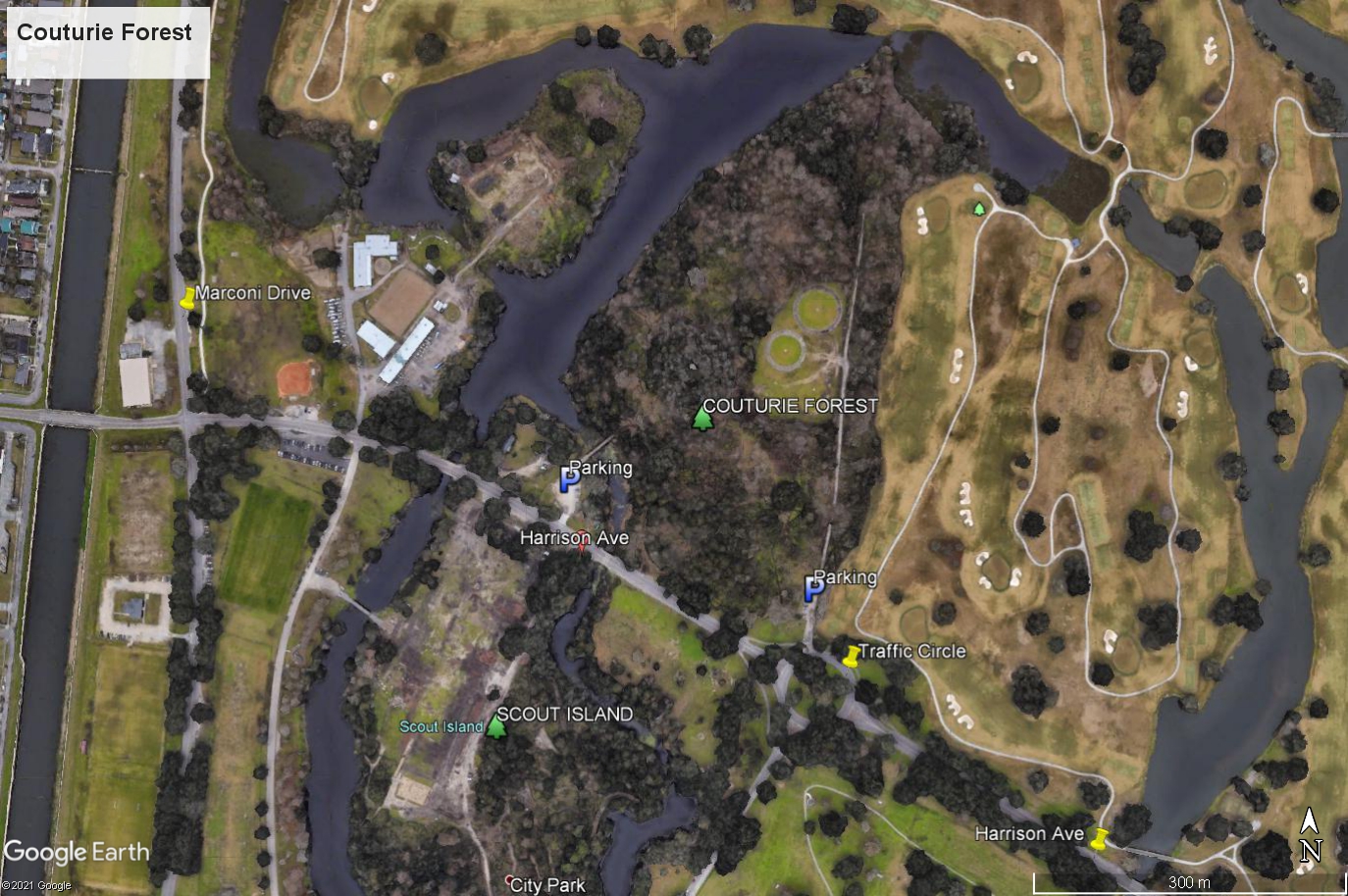
Couturie Forest, 1009 Harrison Avenue
Scout Island and Couturie Forest Trail Map
5. Wisner Tract: Continue east on Harrison Avenue through the traffic circle. After crossing a small bridge over a lagoon, look for a small parking lot on the south side of the road. The trails here are unmarked and can be overgrown and muddy at times. One possible route highlighted in the map below is 1.15 miles long.
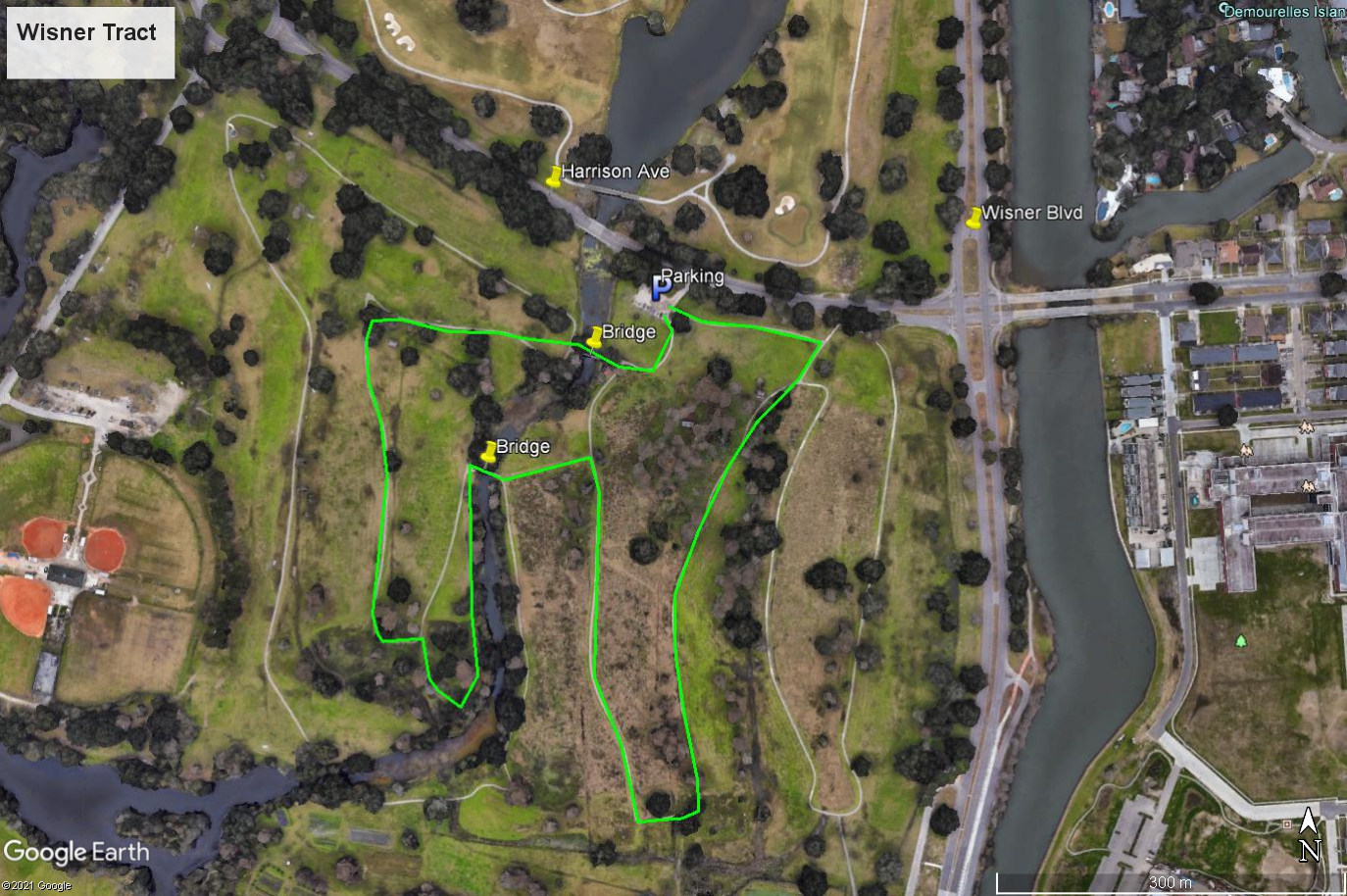
Map of Wisner Tract – One possible route is highlighted.
6. Walking/Biking Trails: On the south side of Harrison Avenue east of the traffic circle, old golf cart tracks wander through open fields of a defunct golf course. Birding can be quite good in the fields as well as in the oaks and lagoons.
7. Bayou St. John: Continue east on Harrison Avenue to Wisner Boulevard and turn left (north). You will be following the bayou here. Scan the bayou for waterfowl and loons in winter. Common Goldeneye and Horned Grebe have been also seen here in winter.
8. Lake Vista: This is a subdivision north of City Park between Marconi Drive and Wisner Boulevard. All of the homes open onto a central park area. Because of its location on the lakeshore and the abundance of trees, this is one of the best spots for migrating passerines in New Orleans. The Canal Lake Vista buses service this area from Canal Street. Simply walk the lanes throughout the subdivision, checking the trees and shrubbery. The area can be good in migration, and has harbored some interesting vagrants in winter. The residents of the area have been most cordial to birders. In order to maintain this relationship, stay on the walkways, and do not enter anyone’s yard or disturb vegetation. If you walk north through the subdivision, you will reach Lakeshore Drive and Lake Pontchartrain. This is a good area for waterfowl in winter.
9. UNO East and West Campuses: The West UNO campus (the main campus) has a tiny woodlot which is a migrant trap after bad weather in the spring. It is located on the NW side of the campus. There are large open fields on both campuses which can be good for shorebirds, primarily after a rain during migration. The west campus is located between Leon C. Simon Drive, Lakeshore Drive, Elysian Fields Avenue, and the London Avenue Canal. It can be reached by the Elysian Fields bus from Canal Street. The London Ave. canal along the west side of the campus can be interesting. The east campus is between Lakeshore Drive, Leon C. Simon Drive and Franklin Avenue. It can be reached by the Franklin Avenue bus from Canal Street. 9. Two lakeshore areas near UNO have high concentrations of gulls in winter. One area is the public boat launch at the Seabrook Bridge, reached by veering right off of Leon C. Simon before the bridge. Lesser Black-backed, Great Black-backed, and Glaucous Gulls have occurred here. The breakwater just east of Bayou St. John where St. Bernard Avenue reaches the lake can also be productive.